
Marshall Tropical Ecology
Belize 2005 - Projects
Mapping Mangrove Communities (Rhizophora mangle, Laguncularia racemosa, Avicennia germinans and Conocarpus erectus) of South Water Caye, Belize
Christopher L. Carson and Dan K. Evans
Herbarium, Department of Biological Sciences
Marshall University, Huntington, West Virginia, USA 25755


Abstract
Mangrove communities were identified and mapped on South Water Caye, Belize. Red mangrove (Rhizophora mangle), White Mangrove (Laguncularia racemosa), Black Mangrove (Avicennia germinans) and Buttonwood (Conocarpus erectus) were located on the Caye. The four species are distant relatives and grouped based on their ecological function to coastal areas. There presence on and around the perimeter of South Water Caye provides a buffer against tropical storms, wave action and excessive erosion. Although a vital ecological component to the structure and function of coastal environments and South Water Caye, Mangrove Communities are at odds with the development of coastal property and access to beaches and the sea. Thirteen populations were identified and located using a Global Positioning System. Historical mapping of South Water Caye from 1961 and 1962 was digitized and 2005 mapping was created from coordinates collected at landmarks around the perimeter of the Caye. The removal of mangroves, specifically Red Mangrove, (Rhizophora mangle) and its extensive prop root system and subsequent beach stabilizing function threatens the continual existence of the current 14.5 acre South Water Caye.
Introduction
South Water Caye is located off the coast of Belize approximately 15 miles east of the town of Dangriga. South Water Caye (pronounced Key) is part of a series of Cayes along Belize’s Barrier Reef that was formed due to cuts or bows in the reef that allowed for the accumulation of sand and the establishment of vegetation. South Water Caye was one of the first Cayes to be developed for tourism in the latter part of the 19th Century.
South Water Caye, a true sand Caye, has continually evolved. At one time Mangroves most likely surrounded the entire perimeter of the Caye with a mangrove wetland environment existing on the north eastern portion of the Caye. Since the 1870’s the Caye has been subdivided into a mixture of private beach house developments and small resorts. Mangrove populations were removed on the majority of the Caye to provide beach access and clear views of the Caribbean Sea. These actions have led to excessive erosion and led many property owners to construct beach stabilization features that would have been naturally accomplished by mangroves.
The International Zoological Expedition (IZE) owns approximately 2 acres of the Caye. IZE is an organization that was started by Fred Dodd, a scientist who wanted to provide access to students, teachers and travelers to some of the more remote areas of Central and South America. IZE provides an educational experience in a sustainable manner and seeks to preserve existing resources for future travelers. The majority of the surviving mangroves on the Caye are located on the east perimeter of property owned by IZE.
The intent of this project is to generate current mapping of the Caye for spatial analysis of existing mangrove populations and compare the surface area of the Caye to historical mapping available from 1960 and 1962. This analysis will add not only to the historical record but to the ongoing efforts of the International Zoological Expedition. The work was accomplished from March 28-30, 2005 as part of a joint expedition to Belize by Alderson – Broaddus College and Marshall University, West Virginia, USA.
Methods and Results
A total of four mangrove species and thirteen populations were located and identified on South Water Caye, Belize from March 28-30, 2005. The species consisted of Red mangrove (Rhizophora mangle), White Mangrove (Laguncularia racemosa), Black Mangrove (Avicennia gergerminans) and Buttonwood (Conocarpus erectus).
Landmarks were identified around the perimeter of the Caye at the land-water contact area and x and y coordinates were recorded for development of base mapping. Approximate width and length and the corresponding x and y coordinates of the relative ends of each population were recorded. All data points were collected using a handheld Garvin Etrex Global Positioning System (GPS). The North American Datum (NAD) 1927 Central America and Universal Transverse Mercator (UTM) Zone 16 with distance units in meters were used to reference the data points into a coordinate system. Three data points were recorded at each site and averaged. Historical Imagery from 1960 and 1961 were photographed on the Caye using a digital camera.
Data points were imported into ArcView 3.2 Geographic Information System (GIS) Software and a spatial layer of the Caye and the mangrove populations were created. Acreage of the Caye was calculated using an acreage script within the GIS software. The spatial layers of the Caye were than imported into ArcGIS 8.3 and maps were created.
The 1960 and 1962 maps were printed and acreage of the Caye for the respective years were calculated using a Planimeter.
Methods and Results cont.
Total acreage for 1960, 1962 and 2005 mapping were 18.9, 14.8 and 14.5 acres, respectively. A calculation of Caye acreage from the ornamental gardens to the northern most portion of the Caye were also calculated. Acreage for this portion of the Caye for 1960, 1962 and 2005 were 9.0, 7.7 and 7.1 acres, respectively.
Red Mangrove (Rhizophora mangle) were found to be the most dominant species of mangrove on South Water Caye. Populations are fragmented throughout the east perimeter of the Caye. The population on the east central portion of the Caye are thriving and are the most connective. The width of these populations vary from 50-70 feet.
One population of Black Mangrove (Avicennia germinans) was located on the Caye. This population comprised a single individual. This is the only identified specimen of Black Mangrove to currently exist on the Caye. Its age most likely dates to the early 20th Century.
A total of four populations of White Mangrove (Laguncularia racemosa) are currently present on the Caye. The populations are fragmented and only 1 or 2 specimens are present within each group.
A fourth species of Mangrove called Buttonwood (Conocarpus erectus) sometimes referred to as White Mangrove was also identified on the Caye. There are three populations of Buttonwood which are fragmented with only 1 or 2 specimens within each grouping that have survived erosion.
Discussion
Populations of Mangroves on South Water Caye are significantly impacted from anthropogenic factors. Mangroves provide a natural and vital ecological component to the stability of coastal environments in Belize. The removal of Mangroves leads to excessive erosion and instability of the shoreline. Mangrove populations on South Water Caye are fragmented with the species Avicennia germinans, Laguncularia racemosa and Conocarpus erectus existing is small populations of 1 or 2 species per group. Red Mangrove (Rhizophora mangle) populations on the lower two thirds of the Caye exhibit the most connectivity between populations. On the northern portion of the Caye property owners have resorted to using manmade feature to secure the banks. A function that could be better performed by Mangrove species, specifically Red Mangrove.
The loss of surface area on South Water Caye will continue to occur without a more sustainable approach to managing development. The 1960 and 1962 mapping exhibits a rapid erosion process. This is most likely an anomaly that can be explained by the period in which the mapping was developed. A tropical storm could have occurred in this 24 month stretch or the mapping was completed during high or low tide and an accurate depiction of the Caye was not able to be determined.
The data from 1960 to 2005 represents a significant decrease in total surface area of the Caye with the northern portion of the Caye undergoing the most significant change in morphology and surface area. This area has periodically required the placement of sand to restore the beach with installation of man-made stabilizing features. Therefore, any calculations of natural loss of surface area due to the removal of mangroves cannot be adequately determined. However, one can assume without this intervention the north eastern portion of the Caye would look substantially different.
References
Balick, Michael J., Michael H. Nee, et al. Checklist of the Vascular Plants of Belize with Common Names and Uses. New York Botanical Garden Press, 2000.
Meerman, J. and W. Sabido. 2001. Central American Ecosystems: Belize. Programme for Belize, Belize City. 2 volumes 50 + 88 pp.
Acknowledgments
The authors would like to extend many thanks to the International Zoological Expedition and specifically to Jen, Mac and the entire staff of IZE South Water Caye. Also, to Dr. Tom Jones and Dr. John Enz for introducing us to the country of Belize.
Figures
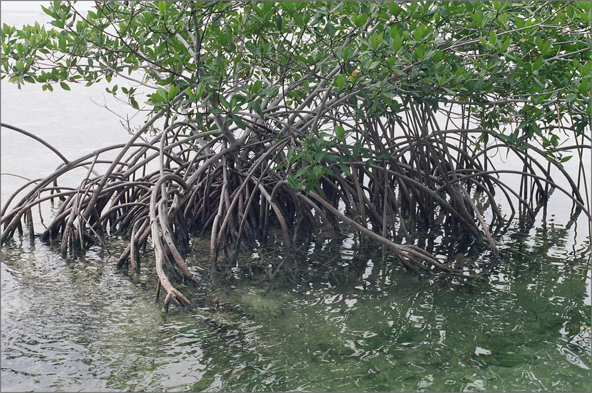
Figure 1. Red Mangrove and an example of bank stabilizing prop roots.
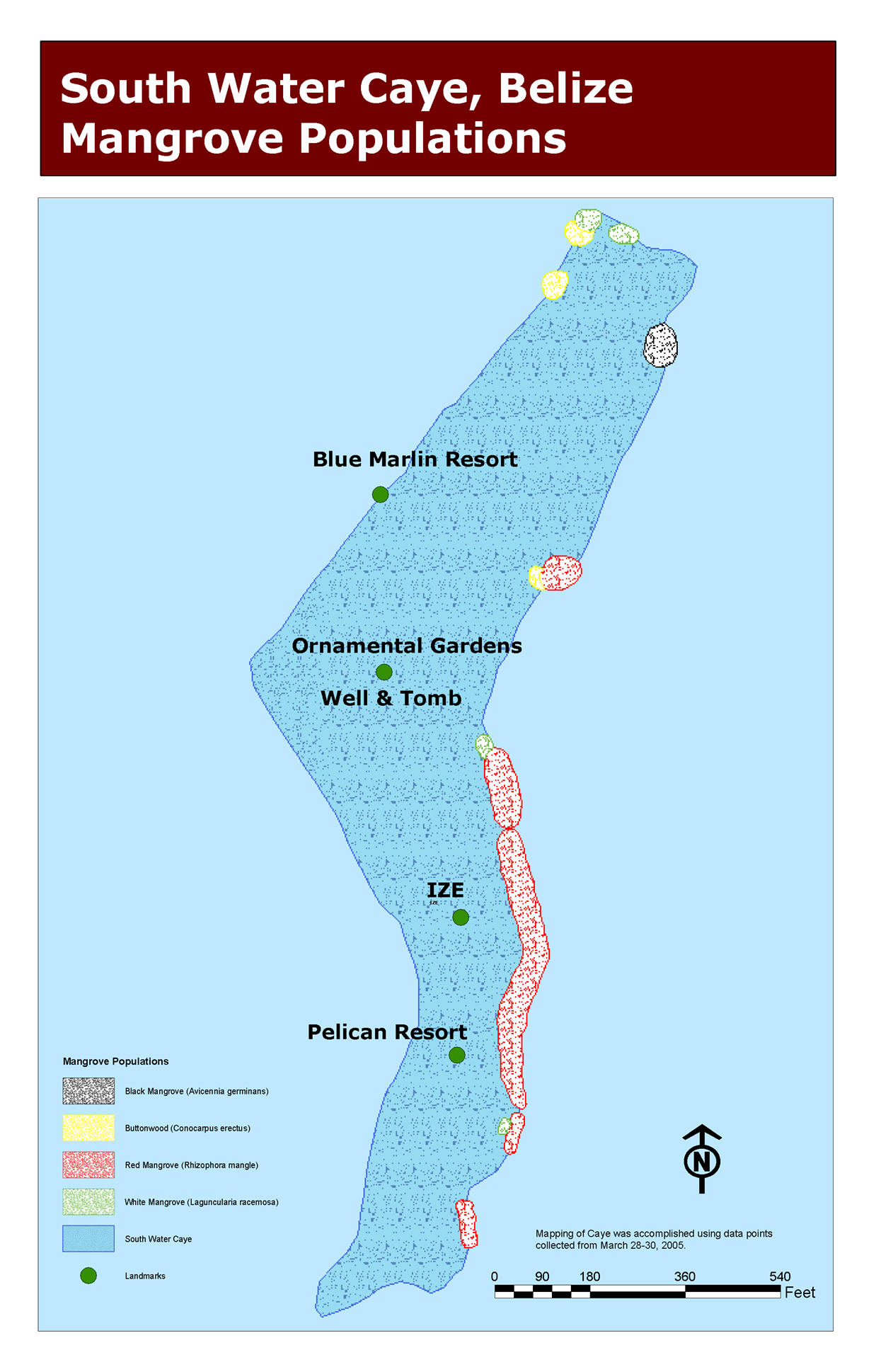
Figure 2. Mapping of thirteen mangrove populations located at South Water Caye, Belize from 28-30 March 2005.
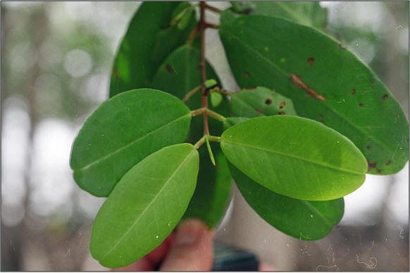
Figure 4.
Leaf structure of
White
Mangrove (Laguncularia racemosa) opposite, smooth, thick, leathery, oblong
rounded at ends 1" to 2" long, dark green on top.
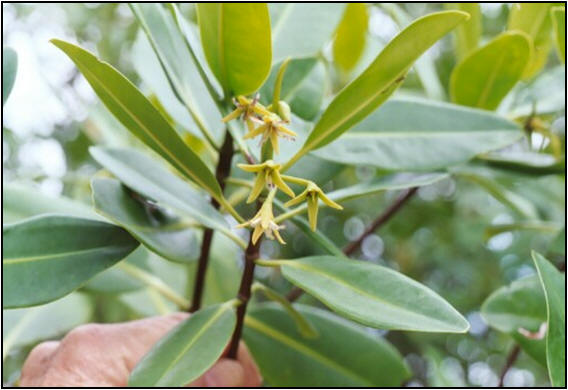
Figure 5. Leaves and flowersof Red Mangrove (Rhizophora mangle).
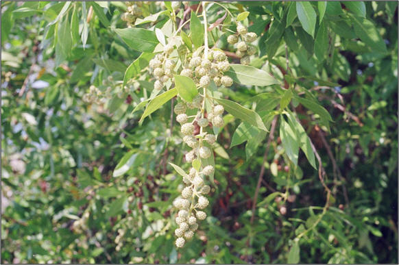
Figure 6. Buttonwood (Conocarpus erectus) fruit clusters are brownish red and have an appearance that resembles buttons.